


| 2016.11.14 |
|
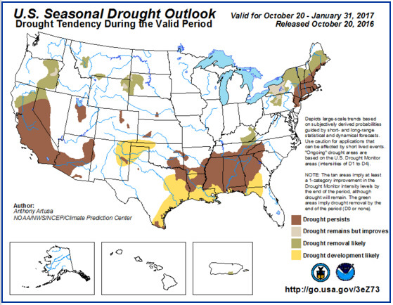
Latest Seasonal Assessment Latest Seasonal Assessment - Over the past 30-days, drought persisted and/or intensified across the Northeast, the interior Southeast, Tennessee Valley, and the Lower Mississippi Valley. Surplus precipitation fell over the Atlantic Coast states from about the Delmarva Peninsula southwestward across the eastern Carolinas to northeastern Florida, resulting from the passage of former Hurricane Matthew almost two weeks ago. Surplus precipitation was also reported across the northern High Plains, the northern Rockies, the Pacific Northwest, and northern California during the past 30-days. The rainy season in the West has gotten off to a good start this year. The seasonal drought outlook valid from October 20, 2016 to January 31, 2017 is based on various precipitation forecasts at various time scales out through 90-days, including WPC's days 1-7 precipitation forecast, CPC's Week-2, Weeks 3 and 4, and 30-day and 90-day outlooks. It is also based on dynamical climate model precipitation forecasts such as the NMME, IMME, and CFS, as well as climatology, and to a limited extent considers typical effects of a weak La Niña on the U.S. during the cold season. La Niña is favored to develop (about a 70-percent chance) during the Northern Hemisphere Fall 2016 and slightly favored to persist (about a 55-percent chance) during winter 2016-17. Across the western contiguous U.S., there is a general model consensus regarding drought improvement and/or removal across eastern Oregon, northern portions of California, and perhaps far northwestern Nevada, with drought expected to persist farther south. In fact, drought improvement and/or removal is anticipated across most drought areas located over approximately the northern half of the Lower 48 states, which is consistent with the notion of frequent low pressure systems and accompanying upper-level troughs. This includes the northern Rockies, the northern High Plains, portions of central Pennsylvania, all but southeastern New York, and the northwestern half of New England. The one exception is over northern New Jersey, southeastern New York, and the southeastern half of New England, where dynamical model guidance does not favor strong indications for drought improvement/removal, but rather drought persistence. The southern half of the contiguous U.S. is predicted to experience overall degradation of drought conditions, with drought persistence or intensification favored. Areas of predicted drought development include portions of the Gulf Coast region, extending across much of eastern Texas, and over parts of the southern High Plains. This latter region has recently experienced warm temperatures and gusty winds, leading to flash drought conditions on a smaller-scale. The only exception to the widespread dryness across the southern Lower 48 states includes eastern parts of both Kentucky and Tennessee, which are expected to be close enough to migratory low pressure systems passing to the north. Elsewhere, small areas of remaining drought in both Hawaii and Puerto Rico are expected to improve and/or be removed during NDJ. The Hawaiian precipitation forecast favors above-median precipitation across the archipelago, while in Puerto Rico, the continuation of the rainy season into November favors the removal of remaining drought across both south-central Puerto Rico and the adjacent island of Vieques. Forecast confidence for both Hawaii and Puerto Rico is moderate to high. Forecaster: Anthony Artusa
|

|
Summary Mild weather once again dominated the majority of the U.S. this past week. Temperatures of at least 10 degrees warmer than normal dominated much of the Plains, Midwest, and Mid-South. Near to slightly below-normal temperatures were confined to New England and south Florida. The drought-stricken areas of the Southeast, southern California, the Intermountain West, and the northwestern Plains received little, if any, precipitation resulting in the persistence or deterioration of drought conditions in these areas. Meanwhile, the coastal Northwest, the south-central U.S., parts of the Midwest, and New England saw rainfall with the passage of a cold front through those areas. |
||

2016.05.01
Severe Weather WatchGlobal Warming brings Climate Change and increasing amounts
of precipitation. Wake up folks!
|


| Hurricane Igor was the most destructive tropical cyclone on record
to strike the Canadian island province of Newfoundland. The origins of Igor
were within a broad area of low pressure that formed on August 26, 2010,
over Ghana. Tracking slowly westward, it developed into a tropical depression
on September 8 and a tropical storm shortly thereafter. Increased wind shear
temporarily halted intensification over the following days. On September
12, explosive intensification took place, with Igor reaching Category 4
status on the Saffir-Simpson Hurricane Wind Scale. A prolonged turn towards
the north was apparent by this time. Peaking with winds of 155 mph (250
km/h), the system gradually weakened before brushing Bermuda as a minimal
hurricane on September 20. Turning northeast, Igor began to transition into
extratropical cyclone, completing this phase within hours of striking southern
Newfoundland. The remnants of Igor were later absorbed by another cyclone
on September 23 over the water between Labrador and Greenland. It resulted in minor damage throughout Bermuda, totaling about $500,000. Later, before becoming an extratropical cyclone, Igor caused significant damage in Newfoundland, roughly $200 million. Due to the extent of damage in Newfoundland, the name Igor was later retired by the World Meteorological Organization and replaced with Ian. |

|
2013.09.15 2013 Hurricane Season2013 Atlantic Hurrincane Season (wikipedia)
TS = Tropical Storm NOAA - National Oceanic and Atmospheric Administration - NHC - National Hurricane Center UCAR - University Corporation for Atmospheric Research
Hurricane WatchNational Weather Service - National Hurricane CentreHurricaneZone.netCurrent Tropical CyclonesNOAA National Weather ServiceStorm Prediction Center |
2011 Mar 31
NASA Earth Observatory - Natural Hazards |
2011 Mar 18
Feeling the Sting of Climate ChangeNASAVideo: 5 min (requires Flash Player) |
2011 May 21
Irish Weather Online |
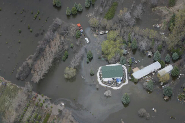
2011.05.14Spring 2011Flood WatchWinnipeg, Manitoba, CanadaLive Flood WebcamsWinnipeg Free Press - Flood Fight 2011 - from the airWinnipeg Free Press - Flood Fight 2011 - from the ground |

|
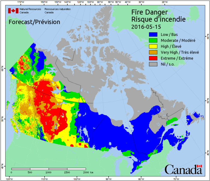
Natural Resources CanadaForest Fires in CanadaOntario Ministry of Natural Resources - Current Forest FiresOntario MNR - Aviation, Forest Fire & Emergency Services
|

02016.05.15
| Creative Commons License | |
Contact | Privacy Policy | Disclaimer | 2008.04.04 - Updated 2014.08.05 |